南海争端究竟是怎么回事? [美国媒体]
quora网友:首先,我们要消除一个深层次的误解:中国并不主张“ 几乎全部”或“整个”南中国海的水域。只有英国主流媒体不停地突出强调这一说法。中国的官方立场是,它要求在九条虚线内的所有的岩石/岛屿/环礁/珊瑚礁的主权。这是一个重大的区别。这意味着在中国控制的12个小岛以外,国际海域船只可以通行无虞......
What is the South China Sea dispute about?
南海争议的来龙去脉是什么?
Alfred W Croucher
China/Taiwan, Vietnam, Japan, the Philippines, and Malaysia all have overlapping maritime territorial claims on the South China Sea.
China's is based on a map published by the KMT around 1947 and tends to claim all seas up to the territorial waters of the other countries, not allowing them any areas of economic influence for oil/gas/mineral exploration. It does look a bit selfish, but then foreign affairs is about the pursuit of a nation's interests along with compromise in order to maintain good relations at best, and avoid war at worst.
When it comes to ceding territory however, most governments, especially those based on a popular mandate, have problems. Indeed it is almost a political impossibility. Nor will they ever allow the matter to be decided by a third party by means of arbitration. China's position formerly was "let's put aside the dispute, and conduct research and exploration in a mutual benefit basis". This failed however as other parties felt that to agree to such a position might prejudice their claims. So over time China became more assertive, allowing Chinese fishing boats to enter the Diaoyu Island waters (Senkaku islands), in order to test Japan's resolve.
The islands then were owned by a private party who was considering to sell them to a metropolitan government which was very reactionary. In order to preempt trouble the Japanese government acquired the islands which China then construed as a provocative act and continued to posture, sending coast guard ships to the waters to bump around with the Japanese boats.
Since then there have been incidents with oil rigs in Vietnam claimed waters and Philippine fishing boats in 'Taiwan" waters. Then the island and light house construction. China continues to assert her claim assertively, if not aggressively. No more the sleeping giant!
即中国/台湾,越南,日本,菲律宾和马来西亚在南中国海都有着重叠的海上领土要求。
中国是以国民党在1947年左右出版的地图为基础的,倾向于把所有其他国家的领海都归到自己名下,不允许他们在南海的石油/天然气/矿产勘探方面产生任何经济影响。这看起来确实有点自私,但外交事务在最好的情况下就是以保持良好的双边关系来追求国家利益和妥协,在最坏的情况下避免发生战争。
然而,当谈到割让领土时,大多数政府,尤其是那些基于民众授权的政府,都会有意见。事实上,这在政治上几乎是不可能的。他们也不会允许这个问题由第三方通过仲裁来决定。中国的立场以前是“搁置争议,在互利基础上进行研究和探索”。然而,其他国家却认为同意这样的立场可能会损害他们的主张,因此这一做法失败了。所以,随着时间的推移,中国变得更加自信了,开始允许中国渔船进入钓鱼岛水域(尖阁群岛),以考验日本的决心。
这些岛屿当时属于一个私人党派,他们正考虑把它们卖给一个非常反动的大都会政府。为了避免不必要的麻烦,日本政府实行了购岛行动,这在中国看来是一种赤裸裸的挑衅,于是继续保持姿态,派出海岸警卫队船只到钓鱼岛水域与日本船只碰撞。
从那时开始,在越南宣称的水域发生了石油钻井以及菲律宾渔船到“台湾”水域捕鱼事件。然后就是造岛和造灯塔。中国积极主动地继续坚持自己的主张,不再是沉睡的巨人!
K Siddhartha
What is South China dispute
As a preemptive measure, China wants a full control over South China Sea. This is the area through which the greatest amount of traffic for India passes. Also the Chinese can think of controlling Malacca Strait from the Pacific side.
China has mastered and manipulated a dispute in South China Sea out of nothing.
China, the Philippines, Vietnam, Brunei, Malaysia and Taiwan all have differing claims on waters and islands.
China claims almost the entire South China Sea through a 'nine-dash line', which extends into other countries' Exclusive Economic Zones (200 nautical miles area for exploitation) . Fears of conflict have risen after the 2012 stand-off between China and the Philippines at Scarborough Shoal.
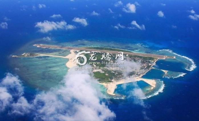
China now building runways, army facilities on reclaimed reefs in the Spratly Islands
Why is South China Sea important?
1.On a strategic level, it's about control of the world's busiest shipping route. China is laying claim to 90 percent of the South China Sea.
2.About half the world's commercial shipping passes through the area and most nations are worried if anything goes wrong then it will cripple their economy.
3.On a geological level, it is about some of the world's most prospective seabed oil and gas deposits.
4.On a military level, it's about China's avid desire to push the US navy away from its coast.
5.The US Seventh Fleet has been unchallenged ruler of the Pacific since World War Two. A fast-rising China is now challenging.
什么是南中国的争端
作为先发制人的措施,中国想要全面控制南海。这对印度来说是海运最繁忙的地区。中国也想通过控制马六甲海峡控制通往太平洋的通道。
中国从无到有,掌握和操纵着南中国海的争端。
中国,菲律宾,越南,文莱,马来西亚和台湾对这些水域和岛屿都有着各自不同的宣称。
中国通过“九段线”几乎声称了整个南中国海,延伸到其他国家的专属经济区之内(200海里开发区)。自中国和菲律宾在斯卡伯勒浅滩(注:即黄岩岛)2012年的对峙之后,世界对冲突爆发的担心已经上升。
中国现在在南海填海造岛,还在上面建机场跑道等军事设施。
为什么南海这么重要?
1.在战略层面上,控制了这里就是控了制世界上最繁忙的航运路线。而中国正在宣称占领南海90%的水域。
2.世界上约一半的商业航运要通过该地区,大多数国家担心如果这里出现任何问题,都会对他们的经济造成打击。
3.在地质层面上,这是世界上最有潜力的海底石油和天然气矿床。
4.在军事层面上,这是关于中国对推动美国海军远离中国海岸的强烈渴望。
5.第二次世界大战以来,美国第七舰队一直是太平洋的统治者。现在一个快速崛起的中国正在挑战它。
Lin Xieyi
First of all we need to dispel a deep-seated misconception : China does not claim "Almost/Virtually/Nearly all" or the "ENTIRE" South China Seas. It is the mainstream English media that keeps highlighting this statement in bold day in and day out. China's official stance is that it claims all rocks/islands/atolls/reefs within the nine dash line. This is a significant Difference. It means that outside the 12NM of Chinese-controlled islands, it is international sea with unfettered access for innocent passage.
With this misconception clarified, we can then proceed to examine the basis on which China claims the islands/reefs/atolls/shoals. China's stance regarding its claim is base on Terra Nullis and Continuity, ie they are the first to discover the islands/reefs/atolls/shoals and has since day one, continued to conduct day-to-day activities such as fishing in that region till today. From this basis China derived its sovereignty over all the islands/reefs/atolls/rocks within the nine dash line.
In an old map published in 1899 by geographer J. Martin Miller (picture above) shows that islands in the South China Sea have never been Philippine territory. The map shows the boundary of the U.S. possession in the Philippines agreed by the United States and Spanish Peace Commissioner at the Treaty of Paris in 1898. The boundaries of the Philippines on the map were marked by a red line, which the South China Sea islands, including the Nansha Islands and the Huangyan Island(Scarborough Shoal), clearly lie out of.
The accusations that China is "not abiding by international law" and "undermining the rule-based international system" cannot hold ground because China made a clear declaration in accordance with the UN Convention on the Law of the Sea (UNCLOS) in 2006 to exclude compulsory arbitration on sovereign disputes and maritime delimitation. More than 30 other countries, including the UK, have made similar declarations.Furthermore, UNCLOS has no jurisdiction over issues of territorial sovereignty. By filing the case to the tribunal, the Philippines showed no good will nor the intention to peacefully solve the South China Sea issue, but only wanted to ramp up political pressure on China. And the so-called arbitration is nothing but a political farce and provocation under the pretext of law especially when the PCA has no affiliation whatsoever with the International court of Justice. Despite the efforts by the Philippines to paint a "David vs Goliath" picture and play the victim, it failed to make a stand on the righteous side.
In short, the problem here is people’s perception of the claims among the littoral countries and the legitimacy of China's claims, which is certainly way more legitimate than claimants who weren't even there in the first place or were late to join in and yet try to claim it as their own.
首先,我们要消除一个深层次的误解:中国并不主张“ 几乎全部”或“整个”南中国海的水域。只有英国主流媒体不停地突出强调这一说法。中国的官方立场是,它要求在九条虚线内的所有的岩石/岛屿/环礁/珊瑚礁的主权。这是一个重大的区别。这意味着在中国控制的12个小岛以外,国际海域船只可以通行无虞。
有了对这个误解的认识,我们就可以继续研究中国所宣称的岛屿/环礁/珊瑚礁/浅滩的主权的基础。中国对其的立场是以无主之地原则和连续性原则为基础的,即他们是第一个发现这些岛屿的人,并且从那开始一直到今天都在这些岛屿上进行比如捕鱼等日常活动。以这个为基础,中国对九段线内所有的岛屿/礁环礁/岩石宣称主权。
在地理学家J.马丁米勒于1899年出版的旧地图中(上图)显示,南中国海的岛屿从来都不是菲律宾的领土。该地图显示了美国和西班牙和平专员在1898年在巴黎条约上同意的关于美国对菲律宾占领的边界。地图上的菲律宾边界以红线标出,南中国海的岛屿,包括南沙群岛和黄岩岛(斯卡伯勒浅滩),显然不在此中。
指控中国“不遵守国际法”和“破坏以规则为基础的国际体系”的说法不能成立,因为中国明确声明,根据2006年联合国海洋法公约(UNCLOS),排除第三方对主权争议和海洋划界的强制仲裁。其他30多个国家,包括英国,也发表了类似的声明。此外,联合国海洋法公约在领土主权问题上并没有管辖权。菲律宾向法庭提交案件,既没有表示善意,也没有表示想要和平解决南海问题的意图,只是想加大国际社会对中国的政治压力。而所谓的仲裁只不过是法律借口下的政治闹剧和挑衅,特别是在PCA与国际法院根本无关的情况下。尽管菲律宾努力画出“大卫vs歌利亚”(注:即弱小的正义对抗强大的邪恶)的画面并扮演受害者的角色,但却没有站在正义的立场上。
总而言之,这个帖子的问题是人们对于南海沿海国家对南海的宣称以及中国的宣称的合法性的看法,中国宣称的合法性当然比那些一开始就与南海无关,或者后来才加入到对南海的宣称然后就把它当作是自己的领土的人的合法性强多了。
Yash Agrawal
South China Sea Dispute every fortnight makes into headlines. I have generally covered the genesis of the dispute and its implications globally. I have tried to cover it in a way so as to understand the problem first hand and also can be used for academic purpose….
Gen
1. Legal rights and privileges guaranteed to sovereign nations by the UNCLOS
2. China has huge interest in pursuing its claim to the islands
3. As sovereign territory of China have fwg rights:
(a) Its law is enforceable up to 12 nm around islands (territorial waters)
(b) All resources in and under the sea up to 200 nm from the islands (EEZ)
4. Hence, both PRC and ROC has claims to these islands
Background
5. The most serious trouble between Vietnam and China and there have also been stand-offs between the Philippines and China:
(a) Paracels Islands
(i) In 1974 the Chinese seized from Vietnam
(ii) Killing more than 70 Vietnamese troops.
(b) Spratlys Islands
(i) In 1988 Chinese seized from Vietnam
(ii) Vietnam losing about 60 sailors.
(c) Scarborough Shoal
(i) 2012 China & Philippines engaged in a maritime stand-off
(ii) Accuse each other of intrusions.
(d) Further Escalations
(i) July 2012 China formally created Sansha city
(ii) An administrative body with its headquarters in the Paracels
(iii) For overseeing Chinese territory in the South China Sea.
(iv) Chinese navy sabotaged two Vietnamese expl ops in late 2012
(v) Intro by China of a drilling rig into waters near the Paracel Islands in May 2014
(aa) Led to multiple collisions with Vietnamese ships
(vi) China building an airstrip on reclaimed land in the Spratlys - Satl Images of early 2015
(vii) Oct 15, US sailed a guided-missile destroyer within 12 nm of the artificial islands
(aa) Planned to assert freedom of navigation in the region.
(ab) China warned US
(e) Rival countries wrangling over territory in SCS for centuries
(f) Tension steadily increased in recent years.
(g) China backed its expansive claims with island-building and naval patrols
(h) Area is becoming a flashpoint with global consequences.
South China Sea Dispute
6. Dispute over:
(a) Territory and sovereignty over ocean areas and
(b) Paracels and the Spratlys
(i) Two island chains claimed in whole or in part by a number of countries.
(c) Dozens of rocky outcrops, atolls, sandbanks and reefs, such as the Scarborough Shoal.
Significance of the Disputed Terrotories
7. The significance of the disputed region is:
(a) Largely uninhabited
(b) Reserves of natural resources around them.
(c) Major shipping route
(d) Fishing grounds that supply the livelihoods of people across the region.
Claims
8. China. Claims by far the largest portion of territory
(a) An area defined by the "nine-dash line"
(b) Stretches hundreds of miles south and east from its most southerly province of Hainan.
(c) In 1947 issued a map detailing its claims.
(d) Showed the two island groups falling entirely within its territory.
(e) Those claims are mirrored by Taiwan.
9. Vietnam. Hotly disputes China's historical account
(a) China never claimed sovereignty over the islands before 1940s.
(b) Has actively ruled over both since the 17th Century
(c) Has documents to prove it.
10. Philippines.
(a) Invokes its geographical proximity to the Spratly Islands
(b) Main basis of its claim for part of the grouping.
(c) Lay claim to the Scarborough Shoal (Huangyan Island as per China)
(d) Little more than 100 miles from the Philippines & 500 miles from China.
11. Malaysia and Brunei
(a) Area falls within their economic exclusion zones
(b) As defined by UNCLOS
(c) Brunei does not claim any of the disputed islands
(d) Malaysia claims a small number of islands in the Spratlys.
World Opinion
12. China favours bilateral negotiations, other countries want international mediation.
13. In ASEAN, dispute has left the bloc severely divided.
14. US has warned China not to "elbow aside" the countries it is in conflict with over the islands.
Implications on India
15. Trade.
(a) About 50 per cent of Indian trade transits through the South China Sea
(b) Very imp for India to ensure that there is absolute freedom of navig
16. ASEAN
(a) India’s relations with ASEAN have improved significantly
(b) Assumed added significance under ‘Act East’ Policy
(c) Some countries involved in the South China dispute
(d) Needs to play a crucial role in its economic development.
17. Resources
(a) Involved in oil and gas exploration in the region.
(b) Indian companies have invested in oil and gas, steel, spices, pharmas, edible oil, sugar, plastics, coffee, consumer products and other sectors.
(c) Wishes peace and security in this region
(d) To meet its energy needs with South China Sea oil and gas
18. Change in Stand
(a) India in the past chose to remain inactive on the South China issue.
(b) China’s aggressive posturing against Indian State-owned Oil Company
(c) Forced a rethink.
(d) China called Indian activities illegal
(e) In July 2011, a Chinese radio massage warned an Indian warship to keep out of ‘Chinese waters.’
19. Encircling India
(a) By deepening its foothold in South Asia and in the Indian Ocean
(b) Unrest in the SCS provides India an opportunity to enlarge its presence
南海争议隔三差五就会成为头条新闻。我大体上总结了一下争端的起源及其在全球造成的影响。我会尝试用一种方法来讨论它,以便第一手了解这个问题,或者用于学术目的……
资料:
1.“联合国海洋法公约”保护主权国家的合法权利和特权
2.中国对拥有这些岛屿有着极大的兴趣
3.作为中国的主权领土中国可以拥有下列权利:
(a)其法律可在海岛(领海)附近12海里以内执行
(b)可以拥有和开发海岛200海里内之下的所有资源(EEZ)
4.因此,中华民国和中华人民共和国都声称拥有这些岛屿。
背景:
6.最严重的情况发生在越南和中国以及中国和菲律宾的对峙上:
(a)西沙群岛
(i)1974,中国人从越南手中夺取了该岛
(ii)杀死了70多名越南士兵
(b)南沙群岛
(i)1980年中国从越南夺取该岛
(ii)越南损失l1约60名船员
(c)黄岩岛
(i)2012年中国与菲律宾进行海上对峙
(ii)双方互相指责对方侵犯了自己的领土
(d)进一步升级
(i)2012年7月中国正式成立三沙市
(ii)在西沙群岛设立一个行政机构总部
(iii)看管中国在南海的领土
(iv)中国海军在2012年末破坏了两艘越南船只
(v)2014年5月,中国将一台钻机引入西沙群岛附近海域
(aa)主导了多次和越南船只相撞的事故
(vi)2015年初,南沙的卫星图象显示,中国在上面开垦土地,建造了一条飞机跑道
(vii)10月15日,美国在人造岛的12海里范围内驾驶一艘导弹驱逐舰
(aa)美国计划在该地区维护航行自由
(ab)中国警告美国
(e)几个世纪以来,相关的竞争国家在南海的领土上争论不休
(f)近年来紧张局势逐步上升
(g)中国以建造岛屿和进行海上巡逻来支持其广泛的要求
(h)该地区正在成为一个造成全球性后果的导火索
南海争端:
6.争议:
(a)对海域和岛屿的领土和主权
(b)西沙群岛和南沙群岛
(i)这两个岛屿被若干个国家宣称完全或部分拥有它的主权
(ii)这里有许多露头的岩石、环礁、沙洲和珊瑚礁,比如黄岩岛
争议领土的意义:
7.有争议地区的意义在于:
(a)大部分岛屿无人居住
(b)它们周围的自然资源储备
(c)位于主要航运路线
(d)有着为整个区域提供生计的渔场
宣称:
8.中国。迄今为止对南海提出了最大的领土要求
(a)“九条线”界定的地区
(b)从最南端的海南省再向南部和东部绵延数百里
(c)1947年发表的一份详细说明其宣称的地图
(d)(该地图)显示两个岛屿完全属于其领土
(e)这些宣称是以台湾为主体的
9 .越南。对中国的历史记录有着强烈的争议
(a)中国在四十年代以前从未宣称过对这些岛屿拥有主权
(b)越南自17世纪以来一直对这些岛屿实行积极的统治
(c)有文件证明
10.菲律宾
(a)它的地理位置更靠近南沙群岛
(b)这是它宣称的主要依据。
(c)要求斯卡伯勒浅滩(中国的说法是黄岩岛)
(d)距菲律宾只有100多英里,远少于距中国的500英里
11. 马来西亚和文莱
(a)这些地区属于其专属经济禁区
(b)根据联合国海洋法公约
(c)文莱没有要求任何有争议的岛屿
(d)马来西亚要求南沙群岛中的少数岛屿
世界舆论
12.中国主张进行双边谈判,其他国家则想要国际调停。
13.在东盟,南海争端已经使该集团严重分裂。
14.美国警告中国不要把和它有岛屿冲突的国家“甩在一边”。
对印度的影响
15. 贸易
(a)约有50%的印度贸易需要通过南中国海
(b)确保在南海有绝对的航行自由对印度来说非常重要
16. 东盟
(a)印度与东盟的关系有了显着的改善
(b)增加了“东方政策”的额外意义
(c)东方政策里的一些国家涉及南中国海争端
(d)印度需要在其经济发展中发挥关键作用
17. 资源
(a)参与该地区的石油和天然气勘探
(b)印度公司投资了石油和天然气,钢铁,香料,药物,食用油,糖,塑料,咖啡,消费品等行业
(c)祝愿这个地区会和平与安全
18. 改变立场
(a)印度过去选择在南中国问题上保持低调
(b)中国对印度国有石油公司采取咄咄逼人的姿态
(c)(印度)被迫重新考虑
(d)中国称印度在南海的活动是非法的
(e)2011年7月,中国无线电警告印度军舰远离“中国水域”
19. 包围印度
(a)通过加深其在南亚和印度洋的立足点
(b)南海动荡给印度提供了扩大其存在的机会
Aishwarya Singh
If you go to work and I occupy your house, does it mean that your house is now mine? China has the power to fish far away from its mainland since before 1400. At that time, Philippine, Vietnam, Malaysia can only fish close to their own land because they didnt have the sailing capability like Chinese did. Hence all the islands in the South China Sea were first discovered and named by the Chinese Ancestors. In 1934, China published its first list of the names of the islands in South China Sea in both Chinese and English.
In 1947, China published its U-shape board line claiming its sovereignty over South China Sea to the whole world and no one opposed. In fact, maps published worldwide, for example, by US in 1962, by the Soviet unx in 1967, by West German, UK, France in 1968, by Japan in 1973,even by Vietnam in both 1960 and 1972, and the Geography text book by Vietnam in 1974, all considered the U-shape board line as valid and considered as under Chinese sovereignty. It is true that some of the islands were taken by countries like Philippines and Malaysia during the time when the communist party and the Kuomintang were fighting with each over who should lead China and neither of them had time to fight for the losing islands. But this doesnt mean these stolen islands should become the thieves territory.
如果你去上班,而我趁机占据了你的房子,那是否意味着你的房子现在是我的了?中国远在1400年以前就拥有了远离大陆去远方捕鱼的能力。而当时的菲律宾,越南,马来西亚只能在靠近自己大陆的地方捕鱼,因为他们没有中国人的航海能力。因此,南海的所有岛屿都是由中国的先祖首先发现和命名的。1934年,中国第一次以中英双文发布了南海诸岛的名称列表。
1947,中国公布了声称南海主权的U形线,全世界没人反对。事实上,世界范围内的地图出版,例如1962年的美国、1967年的苏联、西德、英国、1968年的法国、1973年的日本,甚至1960年和1972年的越南,他们出版的地图和教科书里都承认U型线是有效的,被认为是在中国主权之下的。确实,在共产党和国民党为了中国的领导权打得不可开交无暇估计这些岛屿的时候,菲律宾和马来西亚等国家趁机夺走了一部分,但这并不意味着这些被盗的岛屿应该成为小偷领土。
Anh Khoa Nguyen,
As a citizen of a nation directly related to this issue, I wish to clear everything out here.
First, what is the problem in South China Sea? Simply, it is USA and China playing chess. They both want to have control on this sea, because this sea hasimportant trade routes. While the natural resources and sea ownership and such are important to China, Vietnam, Philippines, Indonesia, etc, the position of the SCS is the thing that is most important. This create incentives for US to join and put pressure to prevent China to control that sea.
The thing is, when China wants to control the sea, they did a very bad move. They tell the world they want to swallow the sea WHOLE. And it pissed off the neighboring countries: Vietnam, my home country, and Philippines are the main countries that are pissed. You can imagine, China claims 3/4 of the sea East of VN to be theirs! The same goes with Philippines in the West. You tell how can we not be pissed?????
I do not discuss about the ownership of the Paracel and Spratly Islands here. In my opinion, no countries should claim ownership of those whole group of islands. However, if you, China, has army to hold them, then Vietnam and Phillippines will have to ignore it. But the thing is that you claiming the WHOLE SCS as your own is ridiculous. This sea should be shared by all the countries related. And THAT is the main point for the lawsuit just now.
作为一个与这个问题直接相关的国家(新加坡)的公民,我希望在这里把一切都捋清楚。
首先,南海的问题是什么?简单地说,就是美国和中国在这里博弈。他们都想控制这片海域,因为这片海域是重要的贸易路线。虽然中国,越南,菲律宾,印度尼西亚等国的自然资源和海洋所有权等都是重要的,但是南海的位置才是最重要的东西。这为美国加入南海争端和为了阻止中国控制海洋而施加压力创造了动力。
问题是,当中国想控制海洋时,他们做了一个非常糟糕的举动。他们告诉全世界他们想完全吞下整个南海。这一举动激怒了邻国:包括越南、我的祖国和菲律宾等主要的东南亚国家。你可以想象,中国宣称越南以东3 / 4的海面都是他们的!菲律宾以西的地区也是如此。你告诉我,我们怎么能不生气???
在这里我不谈西沙群岛和南沙群岛的所有权。在我看来,任何国家都不应该声称拥有整个岛屿群的所有权。然而,如果你,中国,用军队武力控制了这些岛屿,越南和菲律宾也许不得不忍气吞声。但问题是你声称整个南海都是你自己的,这就太荒谬了。这片海域应与所有相关国家共享。这才是南海诉讼的要点。
Scott Bruno
The true problem surrounding the challenges in the South China Sea stems from China dredging up the bottom of the ocean to form islands. Then China claims the new island they just built as well as claiming the surrounding maritime waters surrounding the new island and then they advance to do the same thing again, and again, birthing new islands where ever they seem fit and without regard to any other nation including the UN.
Placed into simple, straight forward and truthful language, China is executing a, "Passive Aggressive Imperial Advance" which is no different than claiming war upon others.
And so the reason we are witnessing the U.S. military sail their ships and fly their planes directly through these territories is due to the nature of someone having to collect evidence now so that if need be in the future there will be solid ground for the use of military force upon any and all aggressors of such nature.
The bottom line is that America is NOT going to stand by idle and watch China roll out this passive aggressive imperialistic advance upon international waters and the rest of the world until eventually we see, "China island" off the coast of New York or Los Angeles.
And now you know the truth of this matter.
在南海造成真正的挑战的是因为中国在南海造岛的行为。然后,中国宣称他们刚刚建成的新岛的主权,并声称新海岛周围的海域,然后他们再次推进同样的事情,并再次分配新的岛屿,而不考虑任何其他国家包括联合国。
最简单、直接、真实地说,中国现在是“被动攻击型帝国主义侵略”,这(些行动)无异于向别人宣战。
所以我们才会看到美国出动他们的军舰和飞机穿越这些地区,这是因为必须有人去收集证据,以便将来面对这种性质的侵略有着万全的军事准备。
底线是美国不会袖手旁观,看中国在国际水域和世界其他地区推行这种被动的帝国主义侵略,否则我们最终也会在纽约或洛杉矶附近看到“中国岛” 。
现在你知道这件事的真相是什么样了吧。
Anonymous
Historically, it was a legacy of sea power invading China’s sphere of influence. When White people first came hundreds of years ago, these southern islanders begged China to protect them. Hundreds of years later, they are begging White people to protect them. They were too foolish to see the trend last time, and still not getting any smarter this time. Philippines is truly the living demonstration of the worst part of Asian culture and worst part of European culture marrying each other.
从历史上看,这是一个海上强国侵略中国的势力范围产生的遗产。几百年前白人刚来的时候,这些南部的岛民恳求中国保护他们。几百年后,他们乞求白人保护他们。他们上一次愚蠢地看不清世界的趋势,今日也没有变得聪明。菲律宾确实是亚洲文化中最糟糕的一部分,也是欧洲文化中最糟糕的一部分。
Anonymous
None of the other answers hit the nail on the head. The nine-dash line showed on Chinese maps means that "hey, the islands, rocks within the line are all mine" , not "hey, these whole waters are mine."
没有一个答案能找到问题的核心。中国地图上显示的九条线意味着“嘿,虚线内的岛屿和石头都是我的”,而不是“嘿,这些水域全是我的”。
Xiao Chen, programmer
China believes it’s dangerous if the US dominates this sea.
The US believes it’s dangerous if China dominates this sea.
中国认为,如果美国势力留在在这片海域是很危险的。
美国认为,如果中国控制了这一海域是危险的。
WiltLavender
If you want the “really” problem, that is American want China do like they want, and China want do like themselves want……
如果你想得到“真正”的问题,那就是美国人希望中国做他们想做的事情,中国则想要做自己想做的事......
版权声明
我们致力于传递世界各地老百姓最真实、最直接、最详尽的对中国的看法
【版权与免责声明】如发现内容存在版权问题,烦请提供相关信息发邮件,
我们将及时沟通与处理。本站内容除非来源注明五毛网,否则均为网友转载,涉及言论、版权与本站无关。
本文仅代表作者观点,不代表本站立场。
本文来自网络,如有侵权及时联系本网站。
阅读:
图文文章RECOMMEND
热门文章HOT NEWS
-
1
Why do most people who have a positive view of China have been to ...
- 2
- 3
- 4
- 5
- 6
- 7
- 8
- 9
- 10
推荐文章HOT NEWS
-
1
Why do most people who have a positive view of China have been to ...
- 2
- 3
- 4
- 5
- 6
- 7
- 8
- 9
- 10


