大西洋月刊:气候变化是否加剧了南加州的大火? [美国媒体]
大规模的山火在加州南部肆虐,威胁着成千上万的家庭和文化地标——比如洛杉矶的盖蒂博物馆。截至周三下午,一些火势最大的大火仍未得到控制。对于这个国家来说,今年是异常糟糕的一年,而对于西部来说,这更是异常糟糕的一年。加州的大火已经摧毁了6000多座建筑,烧毁了数十万英亩的土地。蒙大拿州和不列颠哥伦比亚省也经历了有史以来最严重的山火季节。
Seven of the state’s 10 largest modern wildfires have occurred in the last 14 years.
该州现代的10场最大的森林大火有7场发生在过去的14年间。
Massive wildfires are raging across Southern California, threatening thousands of homes and cultural landmarks like the Getty Museum in Los Angeles. Some of the largest fires were still barely contained by Wednesday afternoon.
大规模的山火在加州南部肆虐,威胁着成千上万的家庭和文化地标——比如洛杉矶的盖蒂博物馆。截至周三下午,一些火势最大的大火仍未得到控制。
It’s been an unusually bad year for the state—amid an unusually bad year for the West at large. Fires in California have destroyed more than 6,000 structures and incinerated hundreds of thousands of acres. Montana and British Columbia both also had some of their worst wildfire seasons ever.
对于这个国家来说,今年是异常糟糕的一年,而对于西部来说,这更是异常糟糕的一年。加州的大火已经摧毁了6000多座建筑,烧毁了数十万英亩的土地。蒙大拿州和不列颠哥伦比亚省也经历了有史以来最严重的山火季节。
Of course, most years are bad wildfire years now. Seven of California’s 10 largest modern wildfires have occurred in the last 14 years. (The state began keeping reliable records in 1932.) Given the scale of the blazes, and their increasing regularity, it makes sense to ask: Does global warming have anything to do with this?
当然,现在的大多数年份都是会发生糟糕的火灾的年份。该州现代的10场最大的森林大火有7场发生在过去的14年间。(该州从1932年开始保留可靠的记录。)鉴于大火的规模以及它们不断增加的规律性,我们有理由问:全球变暖是否与此有关?
The answer isn’t as clear-cut as it was this summer, when drought- and heat-stoked fires raged across the Rockies and Pacific Northwest. Instead, a mix of forces are driving the fires in Southern California, and only some of them have a clear connection to global warming.
答案从未像今年夏天那样清晰——在这段时期里,干旱和高温引发的大火在落基山脉和西北太平洋地区肆虐。相反,现在却有一股力量正在驱动着南加州的大火,而其中只有一部分与全球变暖有明显的联系。
“These fires are not immediately emblematic of climate change,” said John Abatzoglou, an associate professor of geography and climate at the University of Idaho, in an email. “Yes, California did have the warmest summer on record. But the big anomaly here is the delay in the onset of precipitation for the southland that has kept the vegetation dry and fire-prone.”
“这些火灾并不是气候变化的象征,”爱达荷州大学的地理和气候学副教授John Abatzoglou在一封电子邮件中说: “是的,加州的确经历有记录以来最热的夏天。但这里的重大异常是南部地区降水延迟所导致的,这使得植被干燥和易引发火灾。”
In other words, late-fall and winter rains would normally end California’s fire season in November. Because those rains haven’t yet arrived, the blazes continue.
换句话说,晚秋和冬季的降雨通常会在11月结束加州的山火季节。但是因为那些雨还没降临,所以大火还在继续。
“At least in Southern California right now, we are largely seeing textbook wildfires,” said Alexandra Syphard, a senior research scientist at the Conservation Biology Institute who studies fires. “Wind-driven fire events occur most typically in the fall, but can also occur like this, later in the year with fast-spreading, ember-driven fires under Santa Ana wind conditions.”
“至少在南加州,我们在很大程度上看到了一种教科书式的野火,” 生物保护研究所的一名研究火灾的资深科学家Alexandra Syphard说:“风所驱动的火灾事件一般发生在秋天,但也有可能发生在今年晚些时候,在圣塔安娜风的影响下,火势会迅速蔓延。”
Here are some of the biggest factors that are shaping the wildfires in California—and how global warming is or isn’t changing them:
以下是影响加州野火的一些最重要因素,以及全球变暖是在何种程度上改变了它们——或者没有改变它们:
The Santa Ana winds
圣安娜风
Blame for the wildfires in Ventura and Los Angeles counties lies first and foremost with the Santa Ana winds, famously hot and desiccating gusts that blow from the desert to the coast. The Santa Anas also set the stage for the massive wildfires in Napa and Sonoma earlier this year.
在文图拉和洛杉矶县的森林大火中,首当其冲的罪魁便是圣安娜风,这是一种着名的高温干燥大风,从沙漠吹到海岸边。今年早些时候,圣安娜风还为纳帕和索诺马的大规模森林大火搭建了一个舞台。
Fires depend on two variables—an ignition source and fuel to burn—and the Santa Ana winds increase the availability of both. First, they dry out vegetation, creating more fuel across the landscape. Second, they blow trees and other debris against power lines, providing the source of a spark.
火依赖于两种变量——点火源和燃料,而圣安娜风增加了两者出现的概率。首先,它们会使植被干燥,在整个地区产生更多的燃料。其次,它们会把树木和其他的碎片吹到电线上,提供了火花的来源。
When the Santa Anas blow this late in the year, they can start fires. In fact, writes Abatzoglou, “all December fires in the southland since 1948 have been associated with Santa Ana wind.”
当圣安娜风在今年晚些时候开始吹气时,它们也就开始生火了。事实上,Abatzoglou写道:“自1948年以来,南方的12月大火都与圣安娜风有关。”
But there are few signs—at least so far—that the Santa Ana winds are becoming more prent or that they’re systematically moving later in the year. The peak of Santa Ana season usually comes in September or October. There is no trend toward more or fewer Santa Ana fires—or Santa Ana winds generally—in the historical record, Abatzoglou told me.
但是几乎没有什么迹象——至少是如此的遥远的迹象——表明圣安娜风正变得越来越普遍,或者是在今年晚些时候进行着系统性的移动。圣安娜季节的高峰期通常是在9月或10月。Abatzoglou告诉我,在历史上,圣安娜风是没有任何规律趋势的。
A 2006 study from researchers at the University of California and Berkeley National Labs suggested that by the end of the century, Santa Ana winds may become more common. They may also form later in the year, including in December.
加州大学和伯克利国家实验室的研究人员于2006年进行的一项研究表明,到本世纪末,圣安娜风可能会变得更加普遍。它们也可能在今年晚些时候形成,包括在12月。
La Ni?a
拉尼娜现象
There’s currently a weak La Ni?a in the tropical Pacific, which means that global temperatures are cooler than they would be otherwise.
目前在热带太平洋地区有一个很弱的拉尼拉现象,这意味着全球气温要比原本预计的低。
The same phenomenon is also keeping storms from making landfall in Southern California. Normally, California’s wet season would have started by this time of year. “Once [autumn] rains hit the region, fuel moistures recover and make the landscape fire-resistant, thus reducing the odds that a power-line failure or vehicle will start a fire,” said Abatzoglou.
同样的现象也阻止了风暴在南加州登陆。通常情况下,加州的雨季会在每年的这个时候开始。Abatzoglou说:“一旦秋天的雨水降临该地区,那些充当燃料的植被的水分就会恢复,并使这一地区能够抵御火灾,从而减少了电线故障或汽车引发火灾的可能性。”
But the rains haven’t yet appeared, he told me. “So far this autumn, much of the southern half of California is pitching a shutout in terms of rainfall to date. Some of this is characteristic of La Ni?a ... as the southern tier of the United States sees less precipitation during La Ni?a winters.”
但他告诉我,降雨还没有出现:“到目前为止,今年秋天加州南部的大部分地区都在期盼降雨的到来。这里面有着一些拉尼娜现象的特点。在美国南部,在遭遇到拉尼娜现象的冬季,降雨量会减少。”
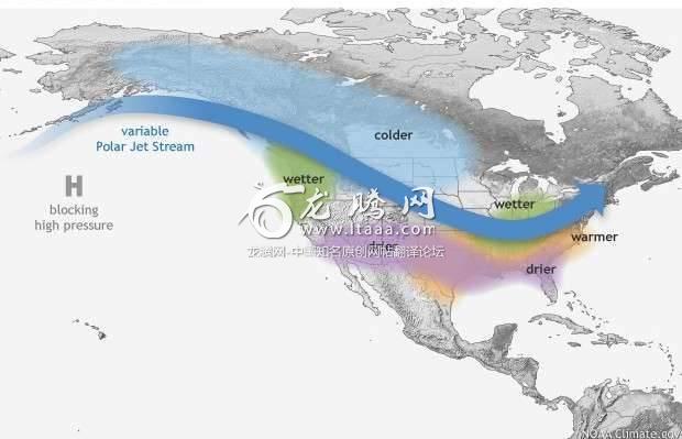
La Ni?a raises the polar jet stream, making the southwestern United States drier than it would be otherwise. (NOAA)
拉尼娜现象提升了极地高速气流,使美国西南地区的气流变得干燥。
It’s still unclear how climate change will affect the Pacific’s yearly dance between El Ni?o, La Ni?a, and a neutral state. A 2015 study in Nature Climate Change found that the Pacific Ocean may careen between extreme states—from an intense El Ni?o to a monster La Ni?a—by the end of the century, but more research on the question still needs to be done.
目前还不清楚气候变化将如何影响太平洋上一年一度由厄尔尼诺现象、拉尼娜现象和中间状态之间都共同完成的舞蹈。一项2015年的自然气候变化研究发现,到本世纪末,太平洋可能会在两个极端状态之间来回摇摆——从剧烈的厄尔尼诺现象到可怕的拉尼娜现象,但这一点仍需要进行更多的研究。
A very cold U.S. East Coast
非常寒冷的美国东海岸
Even as the West Coast remains warm and dry, the Eastern Seaboard is settling into some of its first cold weather of the season. This pattern—a warm West, a frigid East—is known as the North American winter dipole.
即使美国西海岸依然温暖干燥,但是东海岸地区去要开始适应这个季节的第一次寒冷气候。这是由一个温暖的西部和一个寒冷的东部所组成的所谓的北美冬季偶极。
It’s caused when the jet stream—which both ferries storms into the continent and generally divides warm air from cold air—gets especially twisted across North America. It rises far into the Canadian Northwest, keeping most of the western United States warm and dry; then it cascades down across the middle of the country, bringing cold air well into the U.S. Southeast.
它是由高速气流所引起的,它特别是会在北美地区被扭曲——从而进入到这片大陆,把暖空气和冷空气分开。它会上升进入加拿大西北部,使美国西部大部分地区保持温暖和干燥。然后它在跨越这个国家中部地区的时候逐渐下沉,给美国东南部地区带来了冷空气。
This phenomenon prolonged California’s drought during the first part of this decade, keeping any kind of storm system offshore. It also brought the infamous “polar vortex” down into the continental United States.
这一现象延长了加州在这十年的第一个阶段中的干旱,使得任何类型的风暴系统都停留在海上。它还把臭名昭着的“极地涡旋”带到了美国大陆上。
There are a number of theories about how this pattern comes to form, and most of them revolve around climate change, as Jason Samenow writes at The Washington Post.
Jason Samenow在华盛顿邮报上写道:现有很多关于这种模式如何形成的理论,其中大多数都是围绕气候变化展开的。
Daniel Swain, a climate scientist at the University of California, Los Angeles, argues that the ridge forms in part because the West is warming up much faster than the East. If this is the case, then scientists might expect to see the phenomenon fade in decades to come, as the East Coast catches up to the West.
Daniel Swain是加州大学洛杉矶分校的气候学家,他认为,这一气流脊之所以形成,部分原因是西方的升温速度比东部快得多。如果是这样的话,那么科学家们认为:随着东海岸的气温赶上西方,这一现象将在未来几十年里逐渐消失。
But a paper published this week in Nature Communications takes another view. It finds that the disappearance of sea ice over the Arctic Ocean could change the circulation of the Pacific Ocean, encouraging the jet stream to veer north. In other words, climate change will make something like the North American winter dipole keep reappearing.
但本周发表在《自然通讯》上的一篇论文却提出了另一种观点。它发现北冰洋上空的海冰消失可能会改变太平洋的环流,促使高速气流向北转向。换句话说,气候变化将使北美的冬季偶极继续出现。

版权声明
我们致力于传递世界各地老百姓最真实、最直接、最详尽的对中国的看法
【版权与免责声明】如发现内容存在版权问题,烦请提供相关信息发邮件,
我们将及时沟通与处理。本站内容除非来源注明五毛网,否则均为网友转载,涉及言论、版权与本站无关。
本文仅代表作者观点,不代表本站立场。
本文来自网络,如有侵权及时联系本网站。
图文文章RECOMMEND


热门文章HOT NEWS
-
1
Why do most people who have a positive view of China have been to ...
- 2
- 3
- 4
- 5
- 6
- 7
- 8
- 9
- 10
推荐文章HOT NEWS
-
1
Why do most people who have a positive view of China have been to ...
- 2
- 3
- 4
- 5
- 6
- 7
- 8
- 9
- 10
